")
")
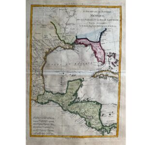

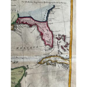
A Rich Look at the Gulf of Mexico and Surrounding Regions
This 1787 map by R. Bonne, published in Paris as part of the Atlas Encyclopédique, offers an in-depth view of the Gulf of Mexico, including Texas, Florida, Louisiana, Eastern Mexico, and the Yucatán Peninsula. It highlights key locations like New Orleans, St. Augustine, Savannah, Veracruz, and Mexico City, as well as native settlements, Spanish missions, rivers, and parts of Central America and the Caribbean. This map captures the geography of a crucial region during the late 18th century.
Historical and Geographical Detail
Bonne’s map reflects both artistic craftsmanship and historical accuracy. The detailed depiction of Spanish missions, rivers, and colonial cities like New Orleans and Veracruz offers insight into the territorial influences of the time. The map also includes features of Central America and the Caribbean, making it a comprehensive representation of the region during the colonial era.
Exquisite Craftsmanship and Condition
Measuring 13 1/2 x 9 1/3 inches, this original hand-colored, copperplate-engraved map is in excellent condition with minor toning. Its authenticity is guaranteed, making it a valuable collectible for history enthusiasts and map collectors alike.