")
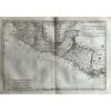
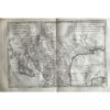
🗺️ 1775-1780 Peru, Bolivia, N. Chile By Bonne & Raynal
- 1775-1780
- By R. Bonne and Raynal
- From ‘Histoire Philosophique et Politique des Établissemens…’
- Part of an important work from the Age of Enlightenment, with contributions from Diderot. The questions, statements, and issues raised in the work on subjects such as religion, commerce, slavery, and contemporary political and social issues resulted in the publication being banned in France.
- As a result, it was published in Geneva, Switzerland.
- Copperplate engraved
- Authenticity Guaranteed
- Overall, very good condition
- 9” x 15
Peru, Bolivia, and northern Chile are depicted on the map, showcasing the Amazon River and its tributaries, Lake Titicaca, and various other geographical features.
This map, crafted between 1775 and 1780 by R. Bonne and Raynal, forms a crucial part of ‘Histoire Philosophique et Politique des Etablissemens,’ a significant work from the Age of Enlightenment, enriched by Diderot’s contributions. The themes explored in this work, ranging from religion to commerce, slavery, and contemporary political and social issues, were so contentious that its publication was banned in France. Consequently, it found its way to Geneva, Switzerland, where it was published. The map, meticulously copperplate engraved, carries an assurance of its authenticity.
Measuring 9” x 15”, it is in excellent overall condition.