

-
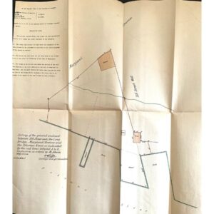
This document originates from a Supreme Court exhibit in Washington, D.C., dating from approximately 1879–1899. It was part of the MORRIS v. UNITED STATES case, which focused on property rights disputes regarding reclaimed land and dredging near the Potomac River. Covering an area of 600 acres west of the Washington Monument, including landmarks like the Lincoln Memorial, Jefferson Memorial, and Potomac Park, the map illustrates the contested territory. Despite its age, it remains in overall very good condition, with authenticity guaranteed. It measures 17 1/2” x 15 1/2”.