")
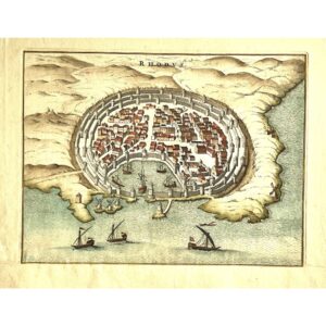
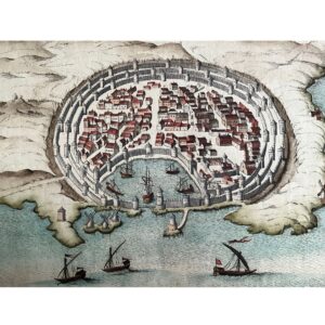
A Stunning View of Rhodes’ Strategic Location
This beautiful bird’s-eye view of the City of Rhodes, created by P. Mortier and based on Blaeu’s earlier work, offers a detailed and captivating representation of this historic city. With the south oriented at the top, the map highlights Rhodes’ impressive three protective walls and its secure harbor, which has been a key Mediterranean port for centuries. From battles to trade, the strategic importance of Rhodes is evident in every intricate detail of this copperplate engraving.
The Iconic Port and Windmills of Rhodes
Outside the city’s protective walls, traditional windmills stand tall, while galleys are depicted both inside the safe harbor and beyond. Rhodes’ harbor has played a significant role in maritime history, and even today, some maritime laws are based on ancient Rhodian customs. This map beautifully captures the city’s connection to the sea, making it an exceptional piece for collectors and maritime history enthusiasts alike.
Exquisite Hand-Colored Engraving
Measuring 7 3/4 x 10 1/4 inches, this original copperplate engraving features stunning hand-colored details that bring the city and its surroundings to life. In excellent condition, the map’s authenticity is guaranteed, making it a valuable and elegant addition to any collection of historical maps or Greek history.