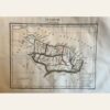
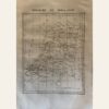
This is a map of India during the British Empire period, created in 1837 by Aristide Perrot. It was published in Paris and is part of the ‘Dictionnaire Universal de Geographie Moderne, Description Physique, politique et Historique de Tours les Leux de la Terre…’ collection. The map features hand-colored and copperplate engraved details. It measures 7 x 10 3/4”. Please note that the internal boundaries shown in the map may not be accurate. The map is in excellent condition and its authenticity is guaranteed.
Sale!