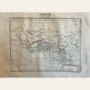
This is a fascinating early post-independence map of Peru and Bolivia from 1837, published in Paris by Aristide Perrot. The map interestingly shows Bolivia as ‘upper Peru’ while today’s Peru is significantly larger in the south and east. It also depicts the early internal divisions of the region.
The map is from ‘Dictionnaire Universal de Geographie Moderne, Description Physique, politique et Historique de Tours les Leux de la Terre’. It is hand-colored and copperplate engraved, and is in overall excellent condition. The dimensions of the map are 7 x 10 3/4”. Its authenticity is guaranteed.