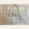
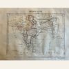
This is a map of the three Guyanas – British, Dutch (Suriname), and French, located in South America. The map was created in 1837 by Aristide Perrot and published in Paris. It is a part of the ‘Dictionnaire Universal de Geographie Moderne, Description Physique, politique et Historique de Tours les Leux de la Terre…’ collection. The map features hand-colored and copperplate engraved details. It measures 7 x 10 3/4”. The map is in excellent condition and its authenticity is guaranteed.
Sale!

1837 Map of The three Guyana’s of South America by A. Perrot
$24.00
1837
By Aristide Perrot
published in Paris
By Aristide Perrot
published in Paris