")
")
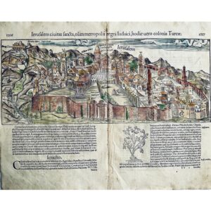
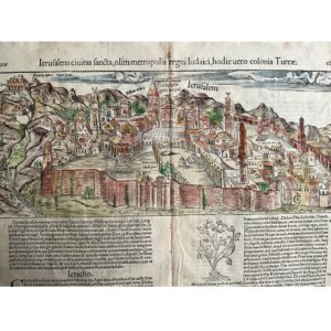

A Glimpse of Jerusalem Through European Eyes
This 1554 map of Jerusalem by Sebastian Munster, published posthumously in Cosmographia, offers a fascinating view of the ancient city. Though not entirely accurate, as it is based on European architectural styles rather than true geographical representation, it provides a unique perspective on how Jerusalem was imagined in the 16th century. Munster’s work has left an indelible mark on geography, and this map is a perfect example of his influence on how cities and continents were depicted during his time.
A Historically Significant Map by One of Geography’s Founders
Sebastian Munster, a theologian and professor, is regarded as one of the three greatest names in 16th-century geography. His adaptation of the name “America” made it widely accepted, and he was the first to create maps of each of the known continents. This view of Jerusalem, part of his Cosmographia, is a testament to his scholarly contribution to geography and his lasting influence in the field. Latin text on the verso includes a map of Ptolemais in Lebanon, adding even more historical depth to this piece.
Hand-Colored Woodblock Engraving in Excellent Condition
Measuring 15 1/3 x 12 1/3 inches (sheet) and 15 x 6 inches (map), this original hand-colored woodblock engraving is in very good condition, with minor tears on the top margins and a center fold repair on the verso. Its authenticity is guaranteed, making it a valuable piece for collectors of historical maps and those interested in the history of Jerusalem.