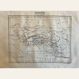
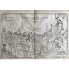
🗺️ 1775-1780 North & South Carolina, Georgia and Virginia By Bonne & Raynal
- 1775-1780
- By R. Bonne and Raynal
- From ‘Histoire Philosophique et Politique des Établissemens…’
- Part of an important work from the Age of Enlightenment, with contributions from Diderot. The questions, statements, and issues raised in the work on subjects such as religion, commerce, slavery, and contemporary political and social issues resulted in the publication being banned in France.
- As a result, it was published in Geneva, Switzerland.
- Copperplate engraved
- Authenticity Guaranteed
- Overall, very good condition
- 14 1/2” x 9 1/2”
This map depicts the early post-Declaration of Independence era of North and South Carolina, Georgia, and Virginia. It includes notable landmarks such as Cape Fear, Cape Lookout, Cape Hatteras, Port Royal, and Savannah, among others. The Appalachian Range marks the western boundaries of the United States, with the Cherokee Nation situated beyond. Created by R. Bonne and Raynal between 1775 and 1780, it is part of the “Histoire Philosophique et Politique des Etablissemens” series, a significant work from the Age of Enlightenment with contributions from Diderot. Due to its controversial content, the publication was banned in France, leading to its release in Geneva, Switzerland. The map is copperplate engraved and comes with a guarantee of authenticity. Overall, it’s in very good condition, measuring 14 1/2 inches by 9 1/2 inches.