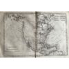
🗺️ 1775-1780 New York, New Jersey, Pennsylvania, Maryland, Virginia and New England States By Bonne & Raynal
- 1775-1780
- By R. Bonne and Raynal
- From ‘Histoire Philosophique et Politique des Établissemens…’
- Part of an important work from the Age of Enlightenment, with contributions from Diderot. The questions, statements, and issues raised in the work on subjects such as religion, commerce, slavery, and contemporary political and social issues resulted in the publication being banned in France.
- As a result, it was published in Geneva, Switzerland.
- Copperplate engraved
- Authenticity Guaranteed
- Overall, very good condition
- 14 1/2” x 9 1/2”
This map covers all the New England states, including New York, New Jersey, Pennsylvania, Maryland, and Virginia, dating back to the early post-Declaration of Independence era. It delineates Lake Ontario, Lake Erie, and the Ohio River, which serve as the western boundaries. Additionally, parts of Maine are labeled as ‘Machasuzet Bay’. Created by R. Bonne and Raynal between 1775 and 1780, this map is part of the “Histoire Philosophique et Politique des Etablissemens” series, which is a significant work from the Age of Enlightenment with contributions from Diderot. Due to its controversial content, the publication was banned in France, leading to its release in Geneva, Switzerland. The map is copperplate engraved and comes with a guarantee of authenticity. Overall, it’s in very good condition, measuring 14 1/2 inches by 9 1/2 inches.