

-
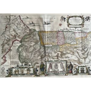
Crafted around 1657 by N. Visscher in Amsterdam, this biblical map portrays the Holy Land, sourced from a Dutch Bible. The map is notable for orienting the Holy Land with north to the right, focusing on the Exodus from Egypt. It features ships in the Mediterranean and Red Seas, as well as Jonah and the whale decorating the sea. Additional decorative elements include the menorah from the temple, a plan of the temple, the Ark of the Covenant, and figures such as Aaron and Moses, with Moses holding the Ten Commandments. The map is hand-colored and copperplate engraved, exhibiting overall good condition despite minor centerfold separation and foxing on the margins. Its authenticity is guaranteed.