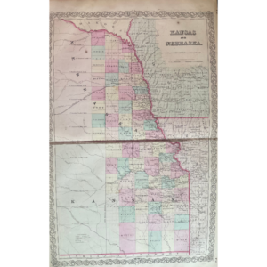


- c1863
- Civil War era
- Virginia and Washington D.C with view of the capital.
- By C. Magnus
- New York
- Shows the capital with the statue of freedom , its first year after placement. The early plans for the Washington Monument are in the background.
- The Virginia map shows the Battle of Bull Run, marked as’rebel positions’, confederate name was ‘Battle of Manassas’, surrounding cities, towns, rivers, and roads are shown.
- Hand colored. Steel engraved
- 7 1/2” x 9”
- Excellent condition
- Authenticity Guaranteed
Around 1863, during the Civil War era, a map showcasing Virginia and Washington, D.C., including a view of the capital, was created by C. Magnus in New York. The depiction features the capital with the newly placed Statue of Freedom, along with early plans for the Washington Monument visible in the background. Notably, the Virginia section of the map highlights the Battle of Bull Run, identified as ‘rebel positions’ (known as the Battle of Manassas by the Confederates), along with surrounding cities, towns, rivers, and roads. This map is hand-colored, steel engraved, measures 7 1/2 x 9 inches, and is in excellent condition, with guaranteed authenticity.