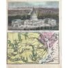
- c1750
- Lima, Peru
- By N. Bellin
- Published in Paris.
- It shows 70 locations in key and is numbered on map.
- The protective walls are long gone
- The Rimac River flows across the lower portion of the map.
- Copperplate engraved.
- Excellent condition
- 14 1/2” x 9”
- Authenticity Guaranteed
Around 1750, a map of Lima, Peru, was crafted by N. Bellin and published in Paris. This map delineates 70 locations with numbered keys. Notably, the protective walls depicted on the map have since disappeared. The Rimac River is depicted flowing through the lower portion of the map. Created through copperplate engraving, this map is in excellent condition, measuring 14 1/2 x 9 inches, and is guaranteed to be authentic.